Now that the first round of the latest winter storm has struck the region, officials say to get ready for round two, which includes dangerously low temperatures tonight and tomorrow morning.
According to the National Weather Service in Norman, an extreme cold warning is in effect for western Oklahoma, including Beckham, Custer, Washita, and Roger Mills counties, from 6:00 PM CST today until noon CST Thursday. Wind chills could reach as low as -25°F, posing a risk of frostbite on exposed skin within 30 minutes.
Beckham County Sheriff Derek Manning says his staff will be extra vigilant while out on patrol during this weather event, ready to assist stranded motorists.
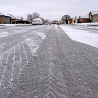
During this latest round of frigid temperatures, which could set records, officials recommend to dress in layers, covering all exposed skin, limit time outdoors to avoid prolonged exposure and to use caution on roads due to potential ice and snow.
Additionally, a Winter Weather Advisory remains in effect until midnight CST tonight, with mixed precipitation expected, including snow and sleet accumulations of up to two inches and ice accumulations of up to one-tenth of an inch.


