Norman, OK – The National Weather Service has issued Tornado Watch 182, effective until 11:00 PM CDT tonight, for several counties including Beckham, Custer, Washita, and Roger Mills. This watch encompasses key areas such as Elk City, Clinton, and Weatherford.
Elevated Severe Weather Risk
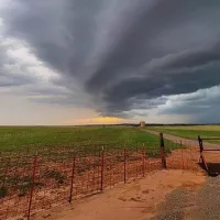
The Storm Prediction Center has placed western Oklahoma under an “Enhanced” to “Moderate” risk for severe thunderstorms this evening. Primary threats include:?
-
Large hail up to baseball size
-
Damaging winds exceeding 70 mph
-
A medium threat for tornadoes, with heightened concern near Clinton and Hobart ?
The most significant weather is expected between 6 PM and 2 AM. Residents are urged to remain vigilant and have multiple ways to receive weather alerts.?
Storm Development Details
According to Mesoscale Discussion 588 from the SPC, conditions are favorable for the development of supercell thunderstorms capable of producing all severe hazards. The environment supports the potential for large hail, damaging winds, and tornadoes, particularly from southwest Oklahoma into the Texas Rolling Plains.
Stay Informed
For continuous updates and live coverage, tune in to KECO 96.5FM or visit kecofm.com. Ensure your NOAA weather radios are operational and set to alert mode.?
Stay safe and prepared as the evening progresses.


