A winter storm is set to bring snow, sleet, and ice to western Oklahoma on Tuesday, impacting travel across Roger Mills, Custer, Washita, and Beckham counties. The National Weather Service in Norman warns of slick roads, reduced visibility, and icy conditions, especially during the morning and evening commutes.
Snow and Ice Forecast for Western Oklahoma
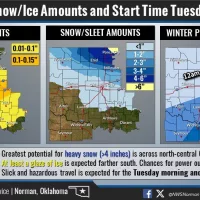
Western Oklahoma will see a mix of snow, sleet, and freezing rain, with the heaviest accumulations expected north of I-40. Areas like Elk City, Clinton, and Weatherford could see 1-3 inches of snow, while towns farther north, including Cheyenne and Leedey, could receive 3-4 inches. Ice accumulations up to 0.15 inches are possible, making roads slick and hazardous.
Timing of the Storm
Midnight – 6 AM: Wintry mix begins in far northwest areas like Cheyenne and Reydon.
6 AM – Noon: Snow and ice spread across Elk City, Sayre, Clinton, and Weatherford, creating dangerous travel conditions.
Noon – 6 PM: Precipitation continues, shifting southward toward Sentinel, Cordell, and Hobart before tapering off Tuesday night.
Travel Impacts and Safety Precautions
The combination of snow and ice will lead to treacherous road conditions. Drivers in Roger Mills, Custer, Washita, and Beckham counties should prepare for slow travel and possible road closures. Power outages remain a low threat, but ice buildup could create isolated issues.
Motorists are urged to avoid unnecessary travel, especially in the morning. If driving is necessary, slow down, allow extra distance between vehicles, and carry an emergency kit with warm clothing, food, and water.
Stay tuned to KECO 96.5 FM for weather updates, road conditions, and closures as the storm moves through the area.


